Posts

Week 16 - Final Hazards Report

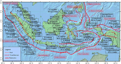
     Due to Indonesia's geography and location, the country is at high risk for various natural hazards, some of which are connected to and exacerbate each other. However, I think the most urgent hazards to address are earthquakes and subsidence.      Indonesia is one of the most seismically active countries in the world due to its location within the ring of fire and on top of multiple subduction plate boundaries. Mitigation of this hazard should be a priority due to the frequency of earthquakes and the devastating effects they can have.  The country experiences thousands of e arthquakes of varying magnitudes each year, with about 320 events with a magnitude of 5 or more and about 3 events with a magnitude of 7 or more annually. Indonesia's seismic activity is heavily concentrated at and around plate boundaries, so these areas, such as the Sumatran coast, should be targeted and receive mitigation help first.       In orde...
Week 13 - Coastal Hazards

      Because Indonesia is made up of over 17,000 islands and has over 99,000 km of coastline, most regions in the country are at high risk of various coastal hazards, the most common of which are coastal flooding and coastal erosion. Due to rising sea levels and unsustainable economic activities resulting in environmental damage, Indonesia loses about 1,950 ha of coastal area to erosion each year. In the past 15 years, about 29,261 ha of coastal area has been lost, which put together is about the size of Jakarta. One of the most significant causes of coastal flooding and erosion is the removal of mangrove forests along the coastline for residential and industrial purposes. Mangrove forests can serve as a buffer to suppress rising tides and waves, preventing coastal flooding, and can stabilize sediments with their roots, preventing coastal erosion. 

Week 8 - Mass Wasting

Image
      Landslides are a frequent occurrence in Indonesia, accounting for one of the highest disaster death tolls in the country.  Indonesia National Disaster Management Authority (BNPB) estimates that 125 million Indonesians, nearly half of the county's population, live in at-risk areas for landslides, with 40 million living in high-risk areas mostly in Java, Sumatra, and the Sulawesi islands.      This hazard can be attributed to Indonesia's high intensity rainfall, many mountainous regions, its geological conditions, and land-use change/land degradation from farming activities. According to a  BNPB spokesperson, irresponsible land-use changes are one of the primary causes of this hazard and increase landslide frequency and strength.      Despite the high occurrence of landslides in Indonesia, the Indonesian government's response to this hazard has been lacking, even compared to the subpar response and mitigation efforts of oth...

Week 5 - Volcanoes

Image
      Indonesia has one of the highest numbers of active volcanoes in the world (at least 124) with approximately 13% of the world's active volcanoes. The island country is dominated by volcanoes formed by subduction of nearby plate boundaries. The majority of Indonesia's volcanoes are located along the Sunda Arc, a volcanic arch stretching 3000 km from Sumatra to Flores that rests atop an active plate boundary where the Indo-Australian plate is subducted beneath the Eurasian plate.      In 1920 the Volcanological Survey of Indonesia was created to investigate, record, and warn about volcanoes in the region, leading to improved monitoring and reporting. VSI now operates a network of 64 volcano observatories to continuously monitor 59 volcanoes. Fairly recently, the Indonesian Center for Volcanology and Geologic Hazard Mitigation has also received assistance from The Volcano Disaster Assistance Program to improve monitoring capabilities throughout the islan...

Week 3 - Earthquakes

Image
    Indonesia is one of the most seismically active countries in the world. This is due to its situation on top of multiple plate boundaries and its location within the ring of fire. The country experiences thousands of earthquakes of varying magnitudes each year, with about 320 events with a magnitude of 5 or more and about 3 events with a magnitude of 7 or more annually. Most of Indonesia's earthquakes are shallower, occurring no deeper than 70 km, but deeper earthquakes are not uncommon. Indonesia's seismic activity is heavily concentrated at or near plate boundaries and increase in depth at major subduction zones.      The largest earthquake to occur in Indonesia was the 2004 Sumatra-Andaman Earthquake. This undersea megathrust earthquake had a magnitude of 9.1-9.3 and reached up to a IX on the Mercalli scale in some areas. It was caused by a rupture along the fault between the Eurasian and Indo-Australian plates and it triggered a devastating tsunami. ...

Week 2 - Tectonics

Image
      Indonesia is located between two continental plates and two oceanic plates and is situated within the Ring of Fire. Most of Indonesia sits on the southeast extension of the Eurasian plate and is bordered to the south and west by the Indo-Australian plate and to the east by both the Pacific and the Philippine oceanic plates.       The northward-moving Indo-Australian plate partially subducts under the eastward-moving Eurasian plate, forming the Sunda trench and the volcanic arc in western Indonesia, which created the islands  Sumatra, Java, Bali, and the Lesser Sunda Islands. Active subduction in this area is responsible for the region's geography, volcanic eruptions, and high concentration of earthquakes.  Block Diagram of Indo-Australian Plate Subduction Beneath Eurasian Plate     The Philippine plate moves northwest, subducting under the Eurasian plate, creating the formation of volcanoes in North Sulawesi, Sangihe...

Week 1 - Introduction to Indonesia

Image
     The Republic of Indonesia, located in both Southeast Asia and Oceania, is the world's largest archipelagic country,  consisting of over 17000 islands, about 6000 of which are inhabited. The country has a population of about 270 million people, making it the world's fourth most populous country. Indonesia lies along the equator and has a relatively even tropical climate all year round with wet and dry seasons and no extreme summers or winters.