Posts

Showing posts from February, 2022

Week 5 - Volcanoes

Image
      Indonesia has one of the highest numbers of active volcanoes in the world (at least 124) with approximately 13% of the world's active volcanoes. The island country is dominated by volcanoes formed by subduction of nearby plate boundaries. The majority of Indonesia's volcanoes are located along the Sunda Arc, a volcanic arch stretching 3000 km from Sumatra to Flores that rests atop an active plate boundary where the Indo-Australian plate is subducted beneath the Eurasian plate.      In 1920 the Volcanological Survey of Indonesia was created to investigate, record, and warn about volcanoes in the region, leading to improved monitoring and reporting. VSI now operates a network of 64 volcano observatories to continuously monitor 59 volcanoes. Fairly recently, the Indonesian Center for Volcanology and Geologic Hazard Mitigation has also received assistance from The Volcano Disaster Assistance Program to improve monitoring capabilities throughout the islan...
Week 3 - Earthquakes

Image
    Indonesia is one of the most seismically active countries in the world. This is due to its situation on top of multiple plate boundaries and its location within the ring of fire. The country experiences thousands of earthquakes of varying magnitudes each year, with about 320 events with a magnitude of 5 or more and about 3 events with a magnitude of 7 or more annually. Most of Indonesia's earthquakes are shallower, occurring no deeper than 70 km, but deeper earthquakes are not uncommon. Indonesia's seismic activity is heavily concentrated at or near plate boundaries and increase in depth at major subduction zones.      The largest earthquake to occur in Indonesia was the 2004 Sumatra-Andaman Earthquake. This undersea megathrust earthquake had a magnitude of 9.1-9.3 and reached up to a IX on the Mercalli scale in some areas. It was caused by a rupture along the fault between the Eurasian and Indo-Australian plates and it triggered a devastating tsunami. ...

Week 2 - Tectonics

Image
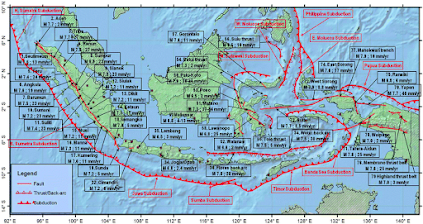
      Indonesia is located between two continental plates and two oceanic plates and is situated within the Ring of Fire. Most of Indonesia sits on the southeast extension of the Eurasian plate and is bordered to the south and west by the Indo-Australian plate and to the east by both the Pacific and the Philippine oceanic plates.       The northward-moving Indo-Australian plate partially subducts under the eastward-moving Eurasian plate, forming the Sunda trench and the volcanic arc in western Indonesia, which created the islands  Sumatra, Java, Bali, and the Lesser Sunda Islands. Active subduction in this area is responsible for the region's geography, volcanic eruptions, and high concentration of earthquakes.  Block Diagram of Indo-Australian Plate Subduction Beneath Eurasian Plate     The Philippine plate moves northwest, subducting under the Eurasian plate, creating the formation of volcanoes in North Sulawesi, Sangihe...